
 Menu
Menu Close
CloseWelcome!
These pages from RNLI Wells' Water Safety Officer offer advice and tips to stay safe and make the most of your visit to our part of the coast, whether you are on on the beach, walking the coast path or out on the water swimming, kayinging or sailing. We now have separate pages for Wells, Blakeney and Morston and Burnham Overy Staithe... though much of the advice applies in all the North Norfolk harbours and beaches and elsewhere along the Norfolk coast too.
Wells Water Safety Map
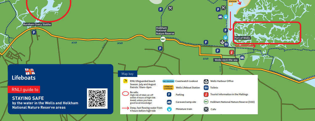 Our updated safety leaflet provides advice and a map for staying safe around the sea on Wells and Holkham beaches and the saltmarshes. You
can download and view or print a PDF version here...
Our updated safety leaflet provides advice and a map for staying safe around the sea on Wells and Holkham beaches and the saltmarshes. You
can download and view or print a PDF version here...
Download the map - updated 27/5/2022
Word Search - Cut off by the tide
 A bit of fun... a word search on a water safety theme for the kids or anyone to occupy a few minutes on a rainy day or busy morning on the holidays or
before you set off to visit on a day trip.
A bit of fun... a word search on a water safety theme for the kids or anyone to occupy a few minutes on a rainy day or busy morning on the holidays or
before you set off to visit on a day trip.
Word Search (PDF)
BBC Radio interview
BBC Radio Norfolk interview, January 2024... Edd Smith chats to visits volunteer Glenda Foster and crew member and water safety officer Mandy Humphries
Download the podcast (mp3 file) to play later.
Marine Police Podcast
A chat with local marine police officer Simon Blakeley about boat safety in Norfolk harbours
Download the podcast (mp3 file) to play later
Don't get cut off by the tide
Advice to avoid being cut off by the tide on beaches and the marsh
One hour either side
Advice for swimmings, rowers and paddlers to avoid the strongest flows on the tide
Water Safety Local Ambassador Scheme - Wells
Liam Fayle-Parr speaks to water safety volunteer Mandy at Wells and the local water safety ambassadors at a local holiday park and tourist centre
A rescue performed by Blakeney Sailing Club
Advice about throw lines in a recent rescue performed by Blakeney Sailing Club members...
Tide Times
To avoid being cut off by the incoming tide on the sands or marshes, make sure you are back on the main Wells beach, coast path or the land-ward side of any channels or drains four hours before the time of high water shown above.
The Royal National Lifeboat Institution (RNLI) is a charity, registered in England and Wales (209603) and Scotland (SC037736). This website is managed and maintained by local volunteers at Wells-next-the-Sea Lifeboat Station and is not the main RNLI site. All text and images copyright (C)2005-2021 RNLI Wells Lifeboat Station, or as indicated, and may not be downloaded, copied or reproduced elsewhere without prior permission of the station or the relevant copyright holder.